content
Meeting Point
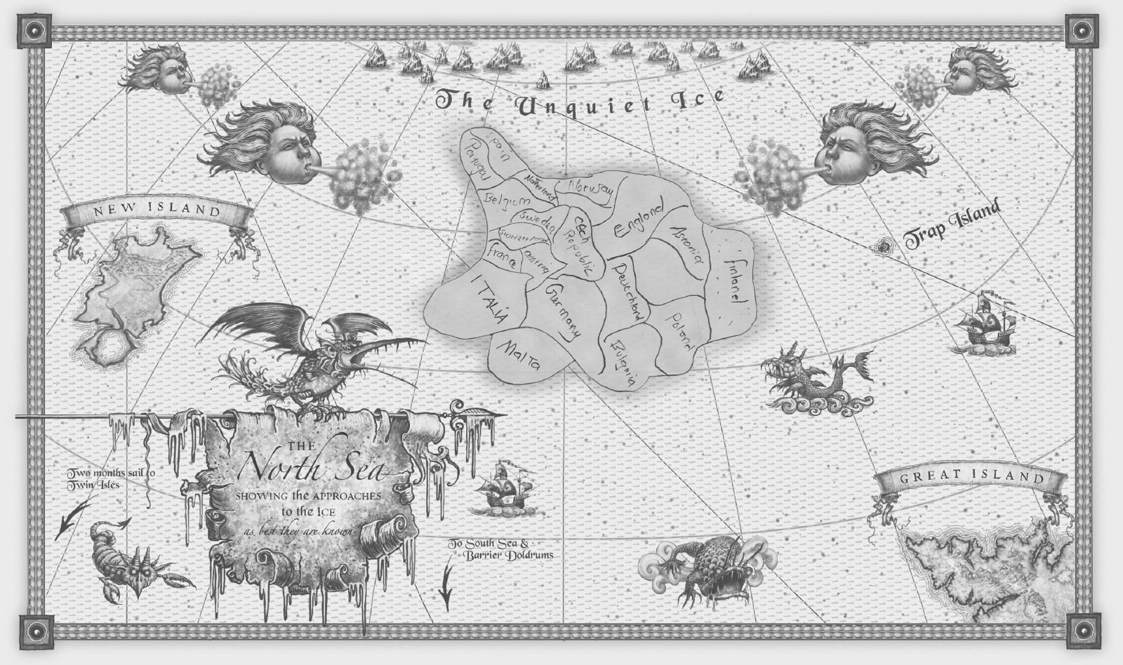
When asked to draw a map of Europe, they don’t refuse: they draw an imaginary shape, which largely deviates from the actual one.
Tomasz Padło
Meeting Point
When asked to draw a map of Europe, they don’t refuse: they draw an imaginary shape, which largely deviates from the actual one. Saare’s drawing is a minute reproduction of his native Eritrea, with a few geographical names thrown in for good measure. Working together, Abdul-Rahman, Ismail and Kamal first draw a figure with a narrow nose and eyes, then their native Sudan. When asked, why they couldn’t drew Europe, they spread their arms in a helpless gesture. Medhane from Eritrea presents a huge Lampedusa, Sicily and a shapeless form situated towards the north of the island; his fellow country man Ismail merely draws a huge Lampedusa and a similarly sized Sicily. Abdul-Hamid seems to be making a sketch of the Continent – the result is a chaotic patchwork of countries with their names written down, which fails to show where they are actually located. In the centre, between Switzerland, Belgium and the Czech Republic, is Sweden, his dream destination. The map also depicted Malta, where his brother – who came to Europe just like him, only that he was captured at sea by a different agency – has stayed for two years. In Abdul-Hamid’s picture, Malta was stuck to Germany and Italy.
The shapes drawn by the refugees do not resemble maps in our sense of the word, because their vision of Europe is completely different. They don’t see it as a geographic object, but they see it as a system of values that is based on prosperity, peace and respect for human dignity. And it doesn’t matter whether their main purpose in life is well-being or security. It brings to mind the research on concepts of Europe carried out as part of the Eurobroadmap project. Russians associated Europe with Ferrari, Mercedes, a cathedral and the Eiffel Tower. However different the connotations may be, they all come down to one thing: Europe stands for worldly happiness.
Europe isn’t easily defined. It clearly exemplifies how challenging it can be to delineate borders. In accordance with the strict regulation set by the International Geographical Union the scope of Europe comprises areas, which people seem not to associate with it, at least from Western cognitive perspective: do Mugodhzar Hills or the valleys of the rivers Kuma and Emba sound equally as exotic as Bukhara, Kandahar, or Hajdarabad. Why is it here that the boundary between Europe and Asia lies? What is so unique about the banks of these two rivers that makes their channels significant enough to divide the world?
Numerous ambiguities gave rise to diverse ideas of how to mark the boundary between Europe and Asia. One of them is based on the assumption that it is mountain range that should constitute a border. Hence the temptation to see the ridge rather than the foot of the Ural Mountains as the edge of the continent. Likewise the main ridge of the Caucasus Mountains seems more obvious than Kuma-Manych Depression that no one has ever heard of.
The advocates of this concept seem somewhat unaware in their departure from physical delineation of space towards social and political divisions, according to which it is difficult to delimit mountain ridges that constitute distinct geological and physiographic regions and form a natural boundary between the varied areas on either side of it. Natural barriers have always been at the core of the division of Europe – political borders are largely based on them, which is why people are automatically inclined to view them this way. The Caucasus divides Europe from Transcaucasia, Russia from Georgia, Armenia and Azerbaijan. However, shouldn’t we see Russia’s neoimperialist aspirations, which are manifested by the progressive annexation of Transcaucasian Abkhazia and South Ossetia, as a violation of the border between Europe and Asia? Hasn’t Georgia – despite its location – got more in common with Europe culturally? Is Chechnya – whose location in the northern part of the Caucasus seems a rather dubious advantage – accordingly more ‘European’ than Armenia? If one introduces cultural and political criteria, perhaps Europe’s borders should be extended to the outer borders of the former USSR – at least in the case of Transcaucasia. Baku, Azerbaijan, organises European Championships and Transcaucasian football teams play under the auspices of UEFA. In this way, sport has anticipated political as well as physical reality, which still doesn’t solve the fundamental question, namely, is the city part of Europe or does it belong to Asia?
Contrary to appearances, delimitation of southern Europe isn’t more obvious. The Mediterranean Sea constitutes a natural, cultural, and political barrier. The problem, however, is in the details. The Strait of Gibraltar separates Europe from Africa in just the same way as it separates Spain from Spain. Should one look for the boundary between the continents in the waters of the Strait – or rather in the European Border Surveillance System (EUROSUR), which separates Morocco and Ceuta? Going further east, is it the Bosphorus that actually divides Europe and Asia, or is it the strongly guarded Turkish-Greek and Turkish-Bulgarian borders? Is Istanbul a European city, as its eulogist Orhan Pamuk sees it, or does it belong to an entirely different culture? And what is the situation of Cyprus? It is located in Asia, but – culturally – its southern part belongs to Europe. Although it is a member state of the European Union, its northern part acknowledges the supremacy of another country, which has not yet entered into the EU. Its inhabitants, on the other hand, are Turkish and they support separatist aspirations, however, they are members of the EU. Thus, we have a situation, where, geographically, the island belongs to Asia, politically, it’s part of Europe, and in fact it is culturally divided in the place, which a British general highlighted on the map in green.
Space is a highly abstract and complex notion. In the discourse on Europe there has been a tendency to define it as a set of values. According to popular opinion, European roots lie in Greek democracy, Roman law, and Christian faith. Some people claim that this set is also comprised of the Napoleonic Code, capitalism, the development of the methodology of natural science, or even the diatonic scale. The problem is that these values have become global a long time ago. These days Latin America is more Christian than Europe, the United States is more capitalist, and Japan is more democratic than, for example, Belarus. Perhaps then Europe should not be defined as a construct based on these values, but more like their birthplace, a setter of trends that the world will (or will be forced to) follow . . . The actual space is not so important as the idea around which people can group.
Bronisław Geremek defined Europe in terms of its resistance to invaders that was based on the fear of Tatars in the Middle Ages, then the fear of Turks, and finally the fear of Communism. Pierre Manent seems to allude to it by claiming that the great European idea was there as long as it was supported by power, also including military power, therefore its weakness today results from the defective sovereignty and the lack of substantive representation. This perspective, however, does not solve the question of European borders, even though it implies the existence of a core of Europe and its peripheries, which are highly vulnerable to attack – that can be very close to the centre, or very far from it.
In popular discourse today Europe is equated with the European Union. Such expressions as: ‘Ukraine’s pro-European policy’, ‘Serbia’s turning away from Europe’, or defining Russia as an opponent make it very clear which countries belong to Europe and which don’t – often contrary to geographical logic. Transnational Europe of values collides with pragmatism of political boundaries.
Among many phenomena, which help shape Europe, has always been the mobility of its inhabitants. Migrations of peoples, military marches, colonisation, economic migrations or mass relocations have become an inherent part of its history. Karl Schlögel points out that one of the determinants of ‘anti-European’ communism involved limiting the natural mobility of Europeans1. Once the restrictions were removed, the migrations revived – and the free movement of persons is now a core principle of the European Union. Europeans have always travelled inside and outside the continent, and they have invited foreign visitors. Europe would have been completely different if it wasn’t for Jews, who have wandered through its cities for the past two thousand years, the Romani who have travelled all the way from Rajasthan to the edge of the Iberian Peninsula, Turks, who have built German economy after the war, or Indians and Pakistanis who have stayed in the United Kingdom after the colonial period. These days, this region is a sort of a dream destination for foreigners – but it isolates itself from them, as if forgetting that it was immigrants who helped create its supremacy over the rest of the world – and the supremacy was actually based on respect for diversity and tolerance. This expansive cultural space, which defines Europe and delineates its actual territory, is at the same time reduced to a very specific, linear border protection system. European politicians keep talking about the search for European roots, which could become a foundation of its identity, however, it seems obvious that political boundaries limit this theoretically unlimited formation.
European borderlands today are symbolised by the flag of the Turkish Republic of Northern Cyprus built with stones into the hillside in the northern side of the demarcation line, the buffer zone between Ukraine and the Donetsk People’s Republic and the Luhansk People’s Republic, the mosque commemorating the conqueror of Constantinople, Sultan Mehmet II, in Kapikule on the Turkish-Bulgarian border, Moroccans camping out by the border fence separating them from Ceuta, hoping to get to the other side when the opportunity arises, and the tiny island of Lampedusa in the Mediterranean Sea, the epitome of the present relationships between Europe and Foreigners, who wish to experience its values.
*
3 kilometres wide and 10 kilometres long, 6,000 inhabitants, less than 130 km from Tunisia and more than 200 km from Sicily. Geographically, Lampedusa is part of Africa, politically, it belongs to Europe – like almost everything in the Mediterranean. According to the International Organization for Migration the number of migrants who have died in the Mediterranean is outrageously high. Between January and September 2014, 3,072 people drowned there. In East Africa, which takes second place on the list, the number of victims was 251. In the case of the U.S.-Mexican borderlands, third on the list, there were 230 victims.
In this context, Lampedusa is unique indeed; the vicinity of Africa coupled with the unstable situation in Libya make it a natural stop on the way to Europe. The island is an attractive place for refugees, but its location is not particularly advantageous from the Italian perspective. This little island mirrors the relationships between Europe and the Third World. A few thousand visitors, chiefly from Italy, are served by a few thousand inhabitants, while, in a local refugee camp hundreds of people are waiting to enter continental Europe. The camp is in the middle of the island, far from the port and the beaches. One might think that it is hidden from public view, especially that it is located in one of two valleys. The neighbour valley has served as a landfill. It seems that these two locations were selected for similar reasons – surrounded by walls and barbed wire fences, the areas are practically cut off from the outside world. The northern shore is inaccessible as cliffs rise above the entire length of it. The southern shore is dominated by leisure infrastructure developed for tourists. In the outermost edges of the island military structures such as the radar station are located. The only town is inhabited by local people working in tourism. Everybody seems to know their place. People don’t protest against unequal division of territory; they only protest against the refugees – as was the case a few years ago, when 2,500 Libyans found themselves in the vicinity of the port and the beach. This upset the balance between the communities and reduced the number of tourists by over 50%. Therefore 800 refugees are now accommodated in a few barracks in a camp, which is closed off and guarded.
Not everyone I’ve asked can draw a map. Some of them have no knowledge of cartography.
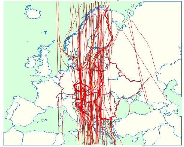
Space as imagined by the refugees is more like a way, which is probably why they ask how long it takes to get to France by boat, or how far it is from France to Germany. During their wanderings so far they did not need to know the outlines, as they have moved along the routes drawn on maps by aid workers. They went from Mogadishu to Addis Ababa, then were transported to Sudan, and then crossed the Sahara in a few weeks to finally reach the Libyan shore. Their perception of the world is reduced to the pragmatically determined route, which doesn’t end here in Lampedusa – but the toughest part of the travel is undoubtedly behind them. Hence, commentators are not entirely right getting soppy over the fate of refugees in Lampedusa, because they have already achieved their major goal and, above all, they feel relieved.
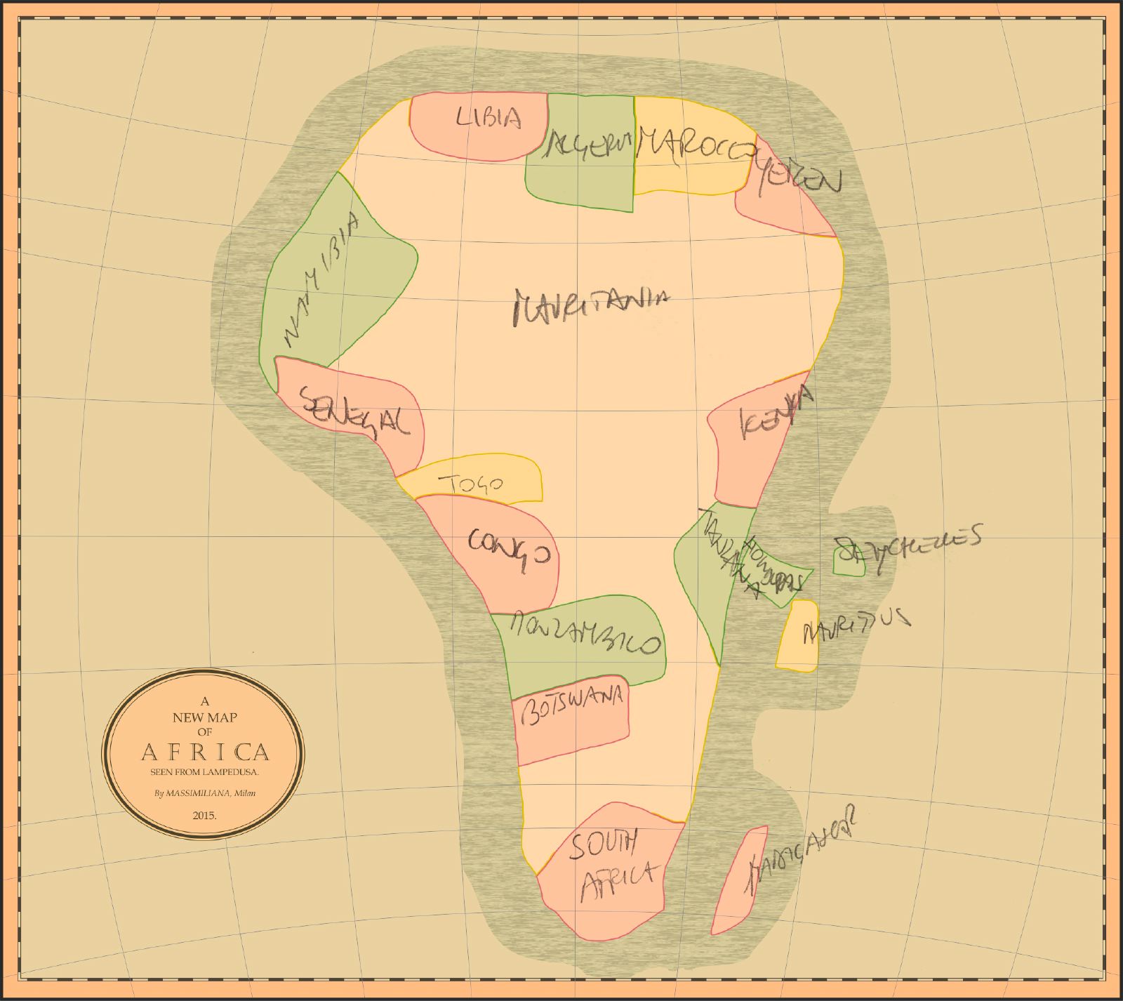
Most people have a tendency to underestimate Africa with respect to its size, as well as significance. This doesn’t compare favourably with Europe, which is typically overestimated 2 despite the fact that, besides Antarctica, it is the least known continent 3. Italian tourists’ notion of Africa differs considerably from their notion of Europe. If they had to draw a map of Africa, most would represent real life accurately. On the one hand, this is due to formal education; on the other hand, due to the fact that people tend to view Africa as a whole entity rather than a more or less chaotic constellation of individual countries. Exception to the rule are the African Mediterranean countries, which – from Italian cognitive perspective – constitute a whole that is inextricably linked with the antique culture. The way people perceive the countries situated south of the Sahara is where the problem begins. They are either non-existent or they make Africa a cake with a hole in the middle. There is also the Republic of South Africa, which is usually perceived as a symbol of the continent that somehow clashes with it in terms of economy. The European stereotype of Africa is relatively comprehensive, specially when compared to stereotypes present among students several decades ago, whose perception of Africa did not go beyond the Republic of South Africa and Ethiopia because of Apartheid and famine, which made the headlines 4. Nevertheless, the depiction of the continent resembles maps of Africa prepared by Europeans in the past 5. Whether we take a look at the map drawn by Abraham Ortelius in 1584, Johann Matthias Hase (1737), or J. Andriveau-Goujon (1856), we’ll see an empty patch in the middle. The interior was inaccessible over centuries, which made it practically unknown. The entire Africa was colonised, however, a special part was played by the coast as it was there that everything the continent had to offer was taken away. The analogy between what is known and what is perceived is not coincidental. Neocolonial notion of Africa also manifests itself in people’s utter ignorance of outlines of its countries, which most Italian tourists won’t even try to draw.
Refugees hide in the shadows. And it’s not because of the heat; it is because they don’t want to be a nuisance to anyone. They are only active within the triangular area between the camp, the port, and the beach – or in fact the rocks near the beach, because they’re too shy to mingle with white tourists. They are extremely quiet, which – compared with expressive Italians – makes them almost invisible. Their demeanour is characterised by a sense of inferiority, they avoid making eye contact with other people. They only move around in groups, multinational, yet homogeneous. There are no conflicts between Muslims from Somalia or Bangladesh and Christians from Ethiopia or Eritrea – or at least they don’t hinder their mutual relationships. The only conflict, albeit peaceful thus far, concerns the representatives of European values and those searching for these values.
Literature
L. Kong, V.R. Savage, T.F. Saarinen, C. MacCabe, Mental maps of the world. The case of Singapore students, ‘Journal of Geography’, 93, 1994, pp. 258-263.
P. Manent, La raison des nations. Réflexions sur la démocratie en Europe, Paris 2006.
T.F. Saarinen, M. Parton, R. Billberg, Relative Size of Continents on World Sketch Maps, ‘Cartographica’, vol. 33, no. 2, pp. 37-48
K. Schlögel, Die Mitte liegt ostwärts. Europa im Übergang, Munich 2002.
P. Wiegand, B. Stiell, Lost Continents? Children’s understanding of the location and orientation of the Earth’s land masses, ‘Educational Studies’, vol. 22, no. 3, 1993, pp. 381-392.
www.theguardian.com/news/datablog/gallery/2012/oct/02/africa-maps-history (13 July 2015)
www.eurobroadmap.eu
1 K. Schlögel, Die Mitte liegt ostwärts. Europa im Übergang, Munich 2002.
2 T.F. Saarinen, M. Parton, R. Billberg, Relative Size of Continents on World Sketch Maps, ‘Cartographica’, vol. 33, no. 2, pp. 37-48
3 P. Wiegand, B. Stiell, Lost Continents? Children’s understanding of the location and orientation of the Earth’s land masses, ‘Educational Studies’, vol. 22, no. 3, 1993, pp. 381-392.
4 L. Kong, V.R. Savage, T.F. Saarinen, C. MacCabe, Mental maps of the world. The case of Singapore students, ‘Journal of Geography’, 93, 1994, pp. 258-263.
5 www.theguardian.com/news/datablog/gallery/2012/oct/02/africa-maps-history (13 July 2015)